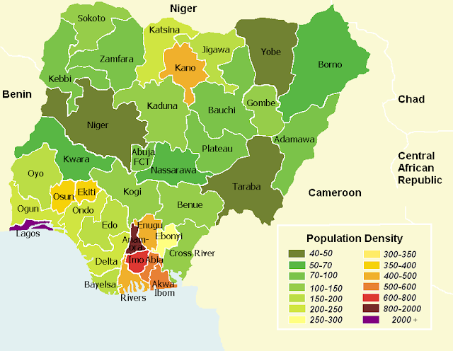
SSC201 ASSIGNMENTS(I) - STATES AND THEIR DETAILS
RIVERS
Rivers State was created out of the former Eastern Region on 27th May 1967 by the then regime of General Yakubu Gowon. Bayels State was carved out of it in the state creation excercise of 1996. It's capital and biggest city is Port Harcourt.
Located in Southern Nigeria, in the delta region, Rivers State covers 11,077 square kilometres. The inland part of Rivers state consists of tropical rainforest; towards the coast the typical river delta environment features many mangrove swamps. Rivers state was part of the Oil Rivers Protectorate from 1885 till 1893, when it became part of the Niger Coast Protectorate. In 1900 the region was merged with the chartered territories of the Royal Niger Company to form the colony of Southern Nigeria.
Rivers State is bounded on the South by the Atlantic Ocean, to the North by the Anambra, Imo and Abia States, to the East by Akwa Ibom State and to the West by the Bayelsa and Delta States.
SOKOTO
GENERAL INFORMATION
Sokoto State was carved out of the then North Western State in February 3, 1976 by the former regime of General Murtala Mohammed. It's capital and largest city is Sokoto. The state is named after its capital Sokoto, a city with a long history and the seat of the Sokoto Caliphate.
Situated in the North Western corner of Nigeria, Sokoto State occupies 25,973 square kilometers. Sokoto State shares its borders with Niger Republic to the North, Zamfara State to the East, Kebbi State to the South-East and Benin Republic to the West.
Even before the arrival of the Fulani, the state concept had evolved in Hausa land. During this process some of the Hausa communities scattered over a wide area, had regrouped themselves into major units that are referred to as kingdoms.
Some of the emergent kingdoms include Kebbi, Zamfara and Gobir, all forming part of Sokoto State.
TARABA
GENERAL INFORMATION
Taraba State was carved out of the former Gongola State on 27th August 1991 by the then regime of General Ibrahim Babangida. Taraba State is named after the Taraba River which traverses the southern part of the state. Taraba's capital is Jalingo.
Situated in the North Eastern part of Nigeria, Taraba State occupies 54,473 square kilometers. Taraba state is bounded in the West by Plateau, Nassarawa and Benue states, on the eastern border by Adamawa State and the Republic of Cameroon, and on the northern border by Gombe State.
Taraba State lies largely within the middle of Nigeria and consists of undulating landscape dotted with a few mountainous features. These includes the scenic and prominent Mambilla Plateau. The state lies largely within the tropical zone and has a vegetation of low forest in the southern part and grassland in the northern part. The Mambilla Plateau with an altitude of 1,800 meters (6000 ft) above sea level has a temperate climate all year round.
YOBE
GENERAL INFORMATION
Yobe State was carved out of Borno State on August 27, 1991 by the then regime of General Ibrahim Babangida. It's capital is Damaturu.
Situated in the North Eastern flank of Nigeria, Yobe State occupies 45,502 square kilometres. Yobe State shares borders with Borno State to the east, Gombe State to the south, Bauchi and Jigawa States to the East and Niger Republic to the north.
Yobe state lies mainly in the dry savanna belt, hence the state is dry and hot for most the year except in the southern part of the state which has a milder climate.
The state is dominated by the Kanuri ethnic group, and is an example of the endurance of traditional political institutions in some areas of Africa. There, the emirs of the former Kanem-Bornu Empire have played a part in the politics of this area for nearly 1000 years.
.
DATA: SOURCE:NIGERIAGELARIA
