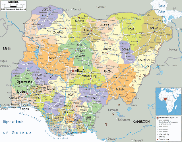
SSC201 ASSIGNMENTS(H) - STATES AND THEIR DETAILS
JIGAWA
GENERAL INFORMATION
Jigawa State was created 27th AUgust 1991 from Kano State by the then regime of General Ibrahim Babangida. Its capital is Dutse.
Situated in central northern Nigeria, Jigawa State covers 23,154 square kilometres and lies between Latitudes 11.00oN to 13.00oN and Longitudes 8.00oE to 10.15oE. Jigawa State shares a common border with Kano and Katsina States to the west, Bauchi State to the south east, Yobe State to the and Republic of Niger to the north.
Jigawa topography is generally characterized by undulating land, with sand dunes of various sizes spanning several kilometres in parts of the State. The southern part of Jigawa comprises the Basement Complex while the northeast is made up of sedimentary rocks of the Chad Formation. The main rivers are Hadejia, Kafin Hausa and Iggi Rivers with a number of tributaries feeding extensive marshlands in north-eastern part of the State. Hadejia “ Kafin Hausa River traverses the State from west to east through the Hadejia-Nguru wetlands and empties into Lake Chad Basin.
KADUNA
GENERAL INFORMATION
Kaduna was created on 27th May, 1967 out of the former Northern region by the then regime of General Murtala Mohammed. Katsina State was created out of it in the state creation exercise of 1987. It's capital is Kaduna.
Kaduna state is located at the centre of Northern Nigeria. It has a political significance as the former administrative headquarters of the North during the colonial era. The state shares boundaries with Niger State to the west, Zamfara, Katsina and Kano states to the north, Bauchi and Plateau States to the east and FCT Abuja and Nassarawa state to the south. Kaduna State occupies 46,053 square kilometres.
Zaria is one of the major towns in Kaduna state and is very rich in history. Queen Amina ruled Zaria and was known as a great warrior, her territories stretching as far to Bauchi in the east and extending as far south as the River Niger. She build a walled town wherever she conquered.
Kadunna State provides the meeting point of the earliest histories of Nigeria. It is the home of Nok which gave its name to the oldest culture of Nigeria - the Nok culture.
KANO
GENERAL INFORMATION
Kano State was created on May 27, 1967 from the then northern region by the then regim of General Yakubu Gowon. Jigawa State was carved out of Kano State in the state creation exercise of 1991. It's capital is Kano.
Located in North-Western Nigeria, Kano State occupies 20,131 square kilometres and is bounded to the north west by Katsina State, north-east by Jigawa State to the north-east, and south by Bauchi and Kaduna States.
KEBBI
GENERAL INFORMATION
Kebbi was formed out of Sokoto State in August 27, 1991 by the then regime of General Ibrahim Babangida. It's capital is Birnin-Kebbi. Its major towns include Birnin-Kebbi, Argungu and Yelwa.
Kebbi State is divided into 21 local government areas , four emirate councils (Gwandu, Argungu, Yauri and Zuru), and 35 districts. Kebbi state derived its name from the 14th century "KEBBI KINGDOM" which was a province of the former Songhai Empire. Islam is the predominant religion.
Located in North Western Nigeria, Kebbi State occupies 36,800 square kilometres. Kebbi State shares boundaries with Sokoto State on the North-Eastern axis, Zamfara State on the Eastern part, Niger state on the Southern part and Republic of Niger on the Western part.
KATSINA
GENERAL INFORMATION
Katsina State was carved out of Kaduna State on September 23, 1987 by the then regime of General Ibrahim Babangida. It's capital is Katsina.
It is made up of two emirates which feature prominently in the establishment of the seven Hausa Kingdoms.
The lineage between Bayajida and Daurama produced the founders of Daura, Katsina, Zaria, Kano, Rano Gobir and Biram. The legendary Kusugu well where the snake called Sarki was slain is one of the tourist attractions of Daura.
Katsina was founded by Kumayo and before the Fulani conquest had been an important seat of learning and a commercial centre of the trans-Saharan Trade. It provided one of the earliest education centres of the north.
Located in northern Nigeria, Katsina State occupies 24,192 square kilometres. Katsina State is bounded in the East by Kano and Jigawa States, in the West by Zamfara State, in the South by Kaduna State and in the North by the Niger Republic. The indigenes are Hausa and Fulani.
KOGI
GENERAL INFORMATION
Kogi State was carved out of Kwara and Benue States on August 27, 1991 by the then regime of General Ibrahim Babangida. It's capital is Lokoja.
Loacted in north central Nigeria, Kogi State occupies 29,833 square kilometres. Kogi State is the most centrally located of all the states of the federation. It comprises the Igala, Ebira, Kabba, Yoruba and Kogi divisions of the former Kabba province. It shares common boundaries with Niger, Kwara, Nassarawa and The Federal Capital Territory to the north. To the east, the state is bounded by Benue state, to the south by Enugu and Anambra States, and to the west by Ondo, Ekiti and Edo states. Lokoja, the Niger/Benue confluence town is the state capital. Ethnically, Yoruba, Nupe and Bassa forming the main ethnic groups.
Kogi State is popularly called the confluence state due to the fact that the confluence of Rivers Niger and Benue occurs there.
